


Using an iPad Mini as a GPSAs my eyes get older, I crave larger displays. I've been using a Nüvi 855 GPS for a few years now, and have been mostly happy with it, but lately I've been wishing for something easier to see. (And something with a more responsive touchscreen—my iPad and iPhone have spoiled me!) Garmin does make a couple of Nüvi models with 7" screens, the 2757 and 2797... but for what you'd pay for one of these, you can just about buy an 8" iPad mini, which needless to say is a much more all-around useful device. (That's especially true if you buy an Apple-refurbished iPad, which can save you anywhere from $40 to $180 off the list price. I've bought several of these over the years, and they are absolutely as good as new merchandise.) (Incidentally, most of what I'll say here also applies to the new iPhone 6 Plus, which has a large enough screen that even my aging eyes are happy with it as a GPS navigator.)
So I convinced myself that if I bought a Mini, I'd be able to use it as a large-screen GPS. (I always like to have an excuse for buying a new "techie toy.") The only hitch was mounting it. My Ford-based motorhome's dash is pretty crowded, and I couldn't just put an 8" tablet up on top of the dash where I'd had the Nüvi 855 mounted—the tablet would stick up so far that it would partly block my view of the road. This article is about how I solved the mounting problem, and how the Mini turned out to be a pretty good GPS navigator—subject to the limitations of the available GPS software, which I'll talk about in detail later in this article. Mounting the MiniMy first attempt to mount the iPad in my motorhome's cab used a Satechi SCH-121 cupholder phone/tablet mount. This well-designed mount has an expanding base that fits very securely in any size cupholder, and a multi-jointed arm ending in a square piece that fits into a slot (think of a camera's accessory shoe, but about twice as big) on the back of its adjustable tablet or phone holder (both are supplied). Each of the two arm joints can be unlocked at the press of a button, repositioned, and will lock when the button is released. As I said, it's a solid design. I placed it in the righthand cupholder (using the lefthand one would have blocked the dashboard stereo) and tried it on a long drive, leaving the Nüvi in its normal position atop the dash. 
I'm used to being able to glance at the Nüvi without moving my head. But with the iPad Mini in the cupholder mount, I had to swivel my head and take my eyes off the road every time I wanted to look at it. That routine got old quickly. I wanted the iPad where the Nüvi was... but of course I didn't want the tablet's larger screen sticking up into my line of sight. And needless to say, I didn't want to block any of the dashboard vents, controls or 12 VDC outlets. So I chose a location on the dashboard that would place the tablet close to my line of sight, yet without blocking my view any more than the old Nüvi did. In practical terms, I positioned it so that the top edge of the tablet was level with the tops of the windshield wipers, since below that, my vision is blocked by the wipers anyway. To begin with, I cut a small (2.8 cm x 6.5 cm) piece of 1/16" aluminum from a scrap that I had been saving, and mounted it to the dashboard with two countersunk screws: 
(You can see a couple of clear plastic bumpers below it; those are to stabilize the mount and prevent any wiggling.) Then I slid on the adjustable holder assembly from my Satechi cupholder mount. This is the part that has the "big accessory shoe" on the back. The piece of aluminum I'd made was just the right size to slide up into the shoe on the back of the tablet holder. 
Now that I had the holder on the dash, all I needed to do was put in the iPad. Here's a view of the rear of the mount, with the iPad (in its microfiber-lined Moko case) in the holder. You can see the aluminum tab in the holder's plastic shoe. 
And here's the finished product in use, running the Garmin U.S.A. app: 
You can see that it doesn't block my view of the road, but it's just as close to my line of sight as the Nüvi was... and even easier to reach, since it's about two inches closer to me. Note: to keep the iPad's battery topped off while driving, I use Griffin's PowerJolt 12 V adapter. Charging an iPad requires twice as much power as charging an iPhone, so be certain that whatever you buy is labeled as putting out 2 amps (or 10 watts). Most common chargers are 1 amp/5 watt models that will not charge an iPad. Be sure you get the right kind! It's all about the softwareFirst, a caution: I've tried a number of GPS navigator apps, both free and paid, and each one has drawbacks. As of late 2014, I've found no perfect solution. Let me summarize the shortcomings I've found, so you won't jump into this unprepared. I'm not talking about inaccurate map databases. Most GPS navigation apps pull their data from one of two or three major sources, and although the companies providing the data work hard to make it as accurate as possible (yes, really!), it's impossible for it to be perfect. Stores close down or move, new roads are built, new housing developments spring up like mushrooms... the mapmakers are always a step behind. We all understand that these maps are not perfect, any more than printed maps are, so the directions given by any GPS device or app must be taken with a grain of salt. One database problem does bear mentioning, because it can lead to big problems for RVers: the mislabeling of road types. Most of us would prefer to avoid driving rough roads with our motorhomes or trailers, or at least not venture onto them unawares. (Someday I'll have to tell you about the time I mistakenly took a 27-foot motorhome towing a car over Fox Creek Trail in rural Tennessee.) But some roads that are tagged as paved in the map databases aren't. When your GPS leads you up such a road, your first impulse is to cuss out the GPS... but it's just doing its best with inaccurate data. There's not much you can do except to use caution, and report such errors to the GPS provider. But the worst problem from my point of view is the difficulty—in some cases outright impossibility—of exporting and importing one's favorite locations. To an RVer, saved waypoints are worth their weight in gold: off-the-beaten-track boondocking sites, propane dealerships, scenic vistas and the like are traded among RVing friends like baseball cards among kids of a certain age. With Garmin's Nüvi series GPS products, you can use Mac OS X or Windows software to back up your saved "favorites" to your Mac or PC, edit them, and when the time comes to upgrade to a newer GPS, export them to the new device. Most GPS apps either can't do this (Garmin U.S.A., Apple Maps, CoPilot), or make the process so cumbersome as to be nearly useless when using the app for driving (Google Maps, Navigon). For an RVer like me, that's extremely frustrating. Of the half dozen GPS apps I've tried over the past couple of years, Garmin U.S.A. has the fewest major flaws. It looks and works very much like a Garmin Nüvi GPS: 
But unlike my Nüvi, the iPad Mini has a big 8" display. And the iPad's multitouch screen is far more responsive than the Nüvi's, which sometimes required a really hard push to register a button press, and was unable to understand the pinch/spread zooming gestures that come naturally to an iPhone or iPad user. The iPad is a pleasure to use, where the Nüvi was sometimes frustrating. The Garmin U.S.A. app isn't cheap. Right now it's selling for $49.99 in the App Store, although it goes on sale for about half that much a couple of times a year. (DealMac.com is a good place to find these bargains; you can even set up an alert so that they'll email you when a specific product goes on sale.) Why pay money?Now, you're probably asking yourself, "Why should I pay for this Garmin app, when Apple Maps and Google Maps are free, and both offer GPS-style navigation?" Well, I've tried all three, and here's my take. When it comes to sitting around looking at possible locations and routes, Apple Maps is pretty good—a lot better than its reputation. Google Maps is good too; in fact, I use it all the time on my iMac to do route planning. But actually driving down the road is a different ballgame. In that situation, I find Garmin U.S.A has a lot of advantages. (It also has some drawbacks that may be important to you; I'll talk about them in minute.) First, the free Apple and Google navigation programs require an internet connection to work, because they have no maps built in—all their data is downloaded. That's OK when you're sitting in an RV park, but when you're driving down the road, it can be a problem. Apple Maps and Google Maps can't get you anywhere without an internet connection to download their maps. But Garmin U.S.A. is completely self-contained. Just like a Nüvi, it contains the entire US street map and points-of-interest databases. Once installed, Garmin U.S.A. doesn't need the internet; it's self-sufficient. I like that. Here's a good example of why that matters: last week I was staying in New Mexico's Coyote Creek State Park, where the only internet connection I could get—even with my Wilson cellular antenna and booster amp—was an extremely slow one that would barely let me read text-only emails. Without a fast internet connection, Google Maps and Apple Maps were completely unusable. How was I to plan my next move? Garmin U.S.A. saved the day. With its built-in maps, it needed no internet connection, so I was able to plot a route to my next destination. Second, Garmin U.S.A. has bigger text, bigger icons... bigger everything. It was meant to run on a phone's small screen, so it's carefully designed so that you can take in everything at a glance. Let's compare the three apps: Garmin U.S.AOn your computer screen, this display may look coarse. But on the dashboard, seen in brief glances, it's just perfect. The text is large and contrasty—easy to read at a glance. The controls are large too—easy to hit with an unsteady fingertip while driving. And all the information you really need is right there. 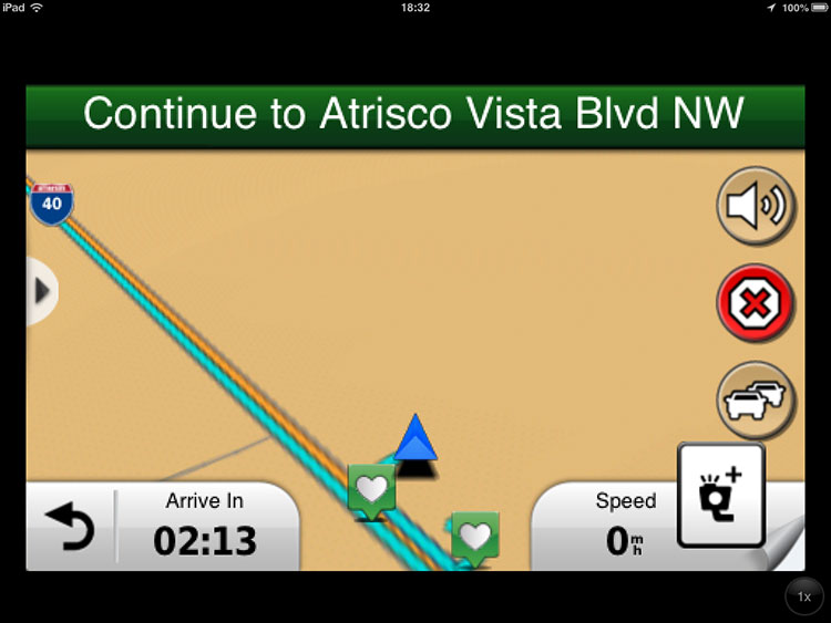
Apple MapsLook at those tiny labels: "Frontage Rd. NW," "Frontage Rd. SW," "66 Pit Stop." I'm sorry, but there's no way I can read text that small at a glance from a couple feet away while driving. Even the main instruction's next-turn presentation is much lower in contrast than Garmin's, and the critical "Start on Frontage Rd NW" instruction is a fraction of the size. OK, it looks just like a road sign. Very pretty. But if I can't read it, what good is it? (Yes, there is a place where you can choose the label size, and I've already set it to the maximum. Still too small!) 
Also notice how little additional information Apple gives you compared to Garmin. Speed? Speed limit? Arrival time? Not there. Oh, wait—the arrival time is there, but it's buried in a thin strip of minuscule type at the top of the screen. Did you see it there? Neither did I, until I was putting this web page together. No wonder—there's no way I could have read that tiny type from a couple of feet away while driving down the road. Google MapsGoogle gets credit for using larger type, but this is still a pretty bare-bones display—a lot less useful than Garmin's. And remember, both the Apple and Google mapping apps require an internet connection before they can even begin to plot a route. Garmin U.S.A. doesn't. 
And back to GarminApple and Google are good at mapping on a computer screen, but a navigational GPS has different needs. That's where Garmin's decades of experience give it a big lead. Let's look again at the Garmin display and see what else it does besides showing a map and telling me where to turn next. 
In addition to the map and the directions, I know how fast I'm going, what the speed limit is (and that sign will flash red if I exceed it), and how long it'll take to reach my destination. When I approach a freeway exit, the app gives me a view of the exit itself, telling me which lane I need to be in (in this case, the lefthand one). 
This "exit view" feature mainly works in urban areas, but that's exactly where you need it. It's a godsend in big-city freeway driving! Did you notice that half-round tab on the left edge of the normal routing screen? Tapping it gets me some really useful additional functions: 
If I hit a detour, one tap on that yellow icon will tell the GPS to reroute me around it. "Where Am I?" not only tells where I am, but also where the nearest hospital, police station and and gas station are, and lets me save my location as a favorite. "Trip Computer" is another familiar Nüvi-style function, and "Map Layers" lets me decide how much information to see. "Glympse" is new to me, and rather interesting. It lets me send a brief message to a friend (e.g.,"I'm on my way")... and the email my friend gets contains a link to a web page that tracks my progress, live! The link expires once I arrive, so it's not going to let my friends track my whereabouts forever—just during my trip. If you've used Apple's "Find My Friend" app, you can think of this as Garmin's version, except that Glympse doesn't just tell where you are... it tells where you're going and when you're expected to arrive as well. Pretty cool, I must admit. 
And hey, check out what the "Exit Services" button gets me: 
Cool! A list of the essential services at the next exit is a great thing to have. I had been using the iExit app for this, but having it built into the GPS is so much better. You can choose to show eating places, gas stations, hotels/motels/RV parks, or all three. Notice that "1/10" at the top? That means the information is for the next exit. But the arrows on either side let me click through a whole series of upcoming exits to see what's available at each one. This is extremely helpful! There's more customizability. For example, notice the "Arrive In" readout at lower left:
Normally on a Nüvi, that display would show my estimated arrival time. But in the Garmin U.S.A. app, if you tap that display, you can choose instead to have it show distance to destination, time to destination, via point arrival time, distance to via point, time to via point, direction of travel, or elevation. I decided that knowing how long till I get there was most useful to me. There are other ways you can customize the app, too. All in all, it's better than any standalone GPS I've ever used... and on the 8" iPad Mini screen, it's really easy on my aging eyes. Garmin U.S.A.'s limitationsUnfortunately, all is not milk and honey. Compared to a standalone Garmin Nüvi GPS, the Garmin U.S.A. app lacks two important features: you can't upload point-of-interest (POI) lists to the app, and you can't export your favorites from the app in order to move them to another GPS device or app. For example, the Ultimate US Public Campground Project offers a file containing more than 20,000 campground locations and descriptions. For less than ten bucks you can download the file and, following the instructions on the website, move it onto your Nüvi or other standalone GPS unit, so that the public campgrounds are shown right on the map as you drive along. Other POI lists available online show things like the locations of all Walmart stores. But there's no known way to get any of these POI lists into the Garmin U.S.A. app. Similarly, when you create a "favorite" location in the Garmin U.S.A. app, it's stuck there—you can't export your favorites to a file or move them to a standalone GPS. Nor can you take the favorites you created on your old Nüvi GPS and import them into your Garmin U.S.A. app. This was a considerable frustration to me when I was making the transition from my Nüvi 855 to the Garmin app running on my iPad. I could export my favorites from the Nüvi to my computer, but I had to manually recreate them in the Garmin app on my iPad. To be fair, as far as I know the same limitations exist in the Apple Maps and Google Maps iOS applications: there's no way to import a list of POIs, and no way to export your favorites to a hardware GPS or to another GPS app. Many savvy RVers rely upon these capabilities, which are standard in most dashboard GPS devices, so why were they omitted from the GPS apps for iPhones and iPads? I don't know. In short, there's no perfect solution, at least at present. I find the combination of the iPad Mini or iPhone 6 Plus and Garmin U.S.A. software works well for me most of the time. But if you rely heavily upon POI lists, or have hundreds of favorites, you may want to stick with a dedicated Nüvi or similar standalone GPS device until the mobile software catches up in functionality. |

© 2013 by Andy Baird. For an index of my other websites, see the andybaird.com homepage.